Musical Geography
  • HOME
  • THE MAPS
  • RESEARCH BLOG
  • THE TEAMS
  • RESOURCES
    • Bibliography
    • Digital Humanities Models
      • Musical Models
      • Historical Acoustics and Sounds
      • Other Humanities Models
    • Archives
      • The Unsuspecting Tour Guide
      • Visualizing Musical Life in 1920s Paris
      • Affective Mapping and the Musical Geography Project
      • Download our Database of 1924 Performances
      • Exhibit at the Alliance Française
      • Invented Primary Sources
      • Literary/Musical Intersections
      • Musical Geography by the Numbers
      • Statistics and Analysis of Beethoven Performances in 1924 Paris
  • ABOUT
    • Rationale
    • Process
    • Problems
    • Press
Select Page

The Atlas of Early Printing

by Thea Brenner | Dec 8, 2020

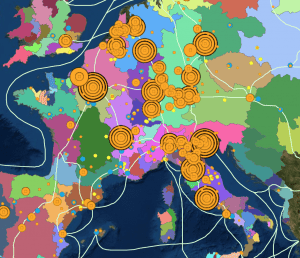
This creation of the University of Iowa provides intuitive interactive mapping through chronological, animated layers that show the spread of printing, paper mills, and other related subjects. Their pop-ups include links to the library’s site to find primary sources.

Recent Posts

  • Sekuru’s Stories
  • 16 Maps That Will Change How You See France
  • Visualizing the Racial Divide
  • USGS Historical Maps
  • The Pompeii Bibliography and Mapping Project

Tags

Aaron Copland advice Americans in Paris archival research Ballets Russes Burleigh challenges in mapping Cinema creating maps Darius Milhaud data data entry Diaghilev diana sinton digital humanities digital maps DUR final reflections First Blog Post Goals Google Maps H.T. Burleigh Harmony Bench Harry T Burleigh HT Burleigh Introduction Jazz Josephine Baker Le Gaulois Map mapping methodology negrophilia Opéra Paris Princesse de Polignac race Reflection Research research methods research process Research Project Resources Slave Songs of the United States Spreadsheet