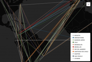
The maps on this research blog are intended both to support research on the dance touring practices by Kate Elswit (in her ongoing collaboration with Harmony Bench) and to inspire new research questions. The maps are “exploratory visualizations” of the American Ballet Caravan’s progress in 1941 South America. The bright lines, circles, and polygons overlaying highlight the possible connections between the dancers on the tour. The maps, and must-read surrounding research blog, bring up interesting questions about the intersections between individual dancers, the company, and the many places to and from which they travel.
Recent Posts
- Reconstructing the t(Ruth): A Biography of Ruth Weatherless
- When Life Gives You Lemons: A Reconstructed Biography of John Cleveland Lemons
- Out of the Field, Into the Rabbit Hole: From Florence Price to Jewel Jennifer – Part II
- Out of the Field, into the Rabbit Hole: From Florence Price to Jewel Jennifer – Part I
- Gladys C. Fearing
Tags
Aaron Copland
advice
Americans in Paris
archival research
Ballets Russes
Burleigh
challenges in mapping
Cinema
creating maps
Darius Milhaud
data
data entry
Diaghilev
diana sinton
digital humanities
digital maps
DUR
final reflections
First Blog Post
Goals
Google Maps
H.T. Burleigh
Harmony Bench
Harry T Burleigh
HT Burleigh
Introduction
Jazz
Josephine Baker
Le Gaulois
Map
mapping
methodology
negrophilia
Opéra
Paris
Princesse de Polignac
race
Reflection
Research
research methods
research process
Research Project
Resources
Slave Songs of the United States
Spreadsheet
You must be logged in to post a comment.