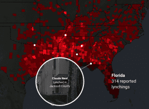
This project presents interecative maps, videos, and reports that engage with the history of lynchings in America. The map itself has two layers: the first shows the number of reported lynchings by county, and the second features the stories of victims, accompanied by video and text. A second map shows a racial breakdown of the U.S., by state, throughout the years of the Great Migration over a period of 60 years (1910-1970). It visualizes how the threats of racial violence affected the travel patterns of many African-Americans. All components of the “Lynching in America” website contribute to “the Report” ⎯ an online resource with additional research and educational materials.
You must be logged in to post a comment.