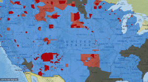
Based on maps produced by the Bureau of American Ethnology in 1899, this interactive, time-sensitive map shows the expansion of United States territory from the late 18th through the late 19th century in terms of land taken from Native Americans, rather than empty land claimed by settlers (as most other maps of this process show.)
Recent Posts
Tags
advice
Americans in Paris
archival research
Ballets Russes
Burleigh
challenges in mapping
creating maps
Darius Milhaud
data
data cleaning
data entry
data entry advice
Diaghilev
diana sinton
digital humanities
digital maps
DUR
final project
final reflections
First Blog Post
Google Maps
H.T. Burleigh
Harmony Bench
Harry T Burleigh
HT Burleigh
Introduction
Josephine Baker
Map
mapping
methodology
negrophilia
Newspapers
Opéra
Paris
Princesse de Polignac
race
Reflection
Research
research methods
research process
Research Project
Resources
Slave Songs of the United States
Specialization
Spreadsheet
You must be logged in to post a comment.