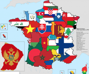
This BuzzFeed article promises to show you 16 maps that will “change how you see France,” and they deliver. From maps that display historical land losses and gains, to ancient maps drawn by monks, or how many kisses it is customary to give in each region, to the spread of the motorway system from 1940. These maps visualize the past and present political, social, and environmental changes in France. Since the page incorporates so many different types of maps (chronological, separated by region, etc.), it gives a well-rounded experience of France that once map alone could not accomplish.
You must be logged in to post a comment.